Gryd


Support this project
Buy Ѧ and:
- [X] Send Ѧ to
AUahWfkfr5J4tYakugRbfow7RWVTK35GPW - [X] Vote
arkyon Ark blockchain and earn Ѧ weekly
Why this package ?
Gryd package provides efficient great circle computation and projection library.
It is light weight (less than 500Ko) and does not rely on dependency.
Documentation
Installation
from source distribution
$ python setup.py install
from pip
$ python -m pip install Gryd
Contribute
Bug report & feedback
Use project issues.
Add / modify / fix code
Guidance words: keep it simple and solid!
- open a issue to propose your contribution
- once issue is granted
- fork this repository
- edit your contribution
- start a pull request
History
2.0.0
- documentation API change
- binary source released
- code improvement
- dump location api change
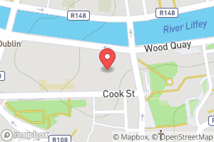
>>> import Gryd
>>> dublin = Gryd.Geodesic(-6.272877, 53.344606, 105.)
>>> # mapbox static map api url
>>> url = "https://api.mapbox.com/styles/v1/mapbox/outdoors-v11/static/"\
...       "pin-s+f74e4e(%(lon)f,%(lat)f)/%(lon)f,%(lat)f,%(zoom)d,0/"\
...       "%(width)dx%(height)d?access_token=%(token)s"
>>> # see https://docs.mapbox.com/api/overview/#access-tokens-and-token-scopes
>>> token = "pk.eyJ1IjoibW91c2lr[...]nJtcHlyejFrNXd4In0.JIyrV6sWjehsRHKVMBDFaw"
>>> dublin.dump_location("test/dublin.png", url, zoom=15, width=300, height=200, token=token)
geohashmodule improvement- implementation based on python integers
- better encryption interface
1.2.0
- added
geohashmodule
1.1.1
Geodesicclass can now dump thumbanil location from google staticmap API- bugfix in unit usage for classic projection (other than grid)
1.1.0
- projection core changes (simpler & faster)
- added
millerandeqcprojection - 64 bit support for Windows
- encrypt/decrypt geodesic coordinates
>>> point = Gryd.Geodesic(-6.23, 53.63)
>>> point.encrypt("your encryption key")
'mwszncbe9g2tu29'
>>> Gryd.decrypt('mwszncbe9g2tu29', key="hacking...") # gives coordinates but not the good ones
Geodesic point lon=+025°22'0.011'' lat=-086°36'35.290'' alt=0.000
>>> Gryd.decrypt('mwszncbe9g2tu29', key="your encryption key")
Geodesic point lon=-006°13'48.000'' lat=+053°37'48.000'' alt=0.000
>>> point
Geodesic point lon=-006°13'48.000'' lat=+053°37'48.000'' alt=0.000
1.0.11
- bugfix for
mgrs.inversefunction utmandmgrsgrid tweaks
1.0.10
Gryd.Geodesicexports itself ingeohash,maidenhead,georefandgarsGryd.Geodesiccreated fromgeohash,maidenhead,georefandgars
1.0.9
bngandinggrid tweaks
1.0.8
- bugfix for
utmandmgrsgrid computation Crs.unitvalue is now used in computation
1.0.7
- Provide a multiplatform wheel (32 and 64 bit for Windows and Ubuntu)
- Python sources released
1.0.6
- Added API doc
1.0.5
- All
Grydobjects are pickle-able
>>> import pickle
>>> data = pickle.dumps(wgs84)
>>> data
b'\x80\x03c_ctypes\n_unpickle\nq\x00cGryd\nEllipsoid\nq\x01}q\x02X\x04\x00\x00\x00nameq\x03X\x06\x00\x00\x00WGS 84q\x04sC(v\x1b\x00\x00\x00\x00\x00\x00\x00\x00\x00@\xa6TXA\xd0\x97\x1c\x14\xc4?XA\x9a\xaf\xda<\x1a\xf2\xb4?(\xe1\xf3\x84Zwk?q\x05\x86q\x06\x86q\x07Rq\x08.'
>>> pickle.loads(data)
Ellispoid epsg=7030 a=6378137.000000 1/f=298.25722356
1.0.4
- bugfix
Gryd.Vincenty_destrepresentation - wheel distribution fix
1.0.3
- linux (ubuntu) fix
1.0.2
Gryd.Geodesicclass takes degrees arguments for longitude and latitude values- better objects representation
- speed improvement
- added
__float__operator forGryd.DmsandGryd.Dmmobjects
>>> float(Gryd.Dms(1, 5, 45, 23))
5.756388888888889
>>> "%.6f" % Gryd.Dms(-1, 5, 45, 23)
'-5.756389'
1.0.1
- minor changes in C extensions
- bugfix
geoid.dmsandgeoid.dmmfunction
1.0.0
- first public binary release (
win32andlinuxplatform)